yahoo Press
Storms battered the Midwest. Now giant hail, tornadoes loom Tuesday
Images

1 / 10
2 / 10

3 / 10

4 / 10

5 / 10

6 / 10
7 / 10

8 / 10

9 / 10

10 / 10
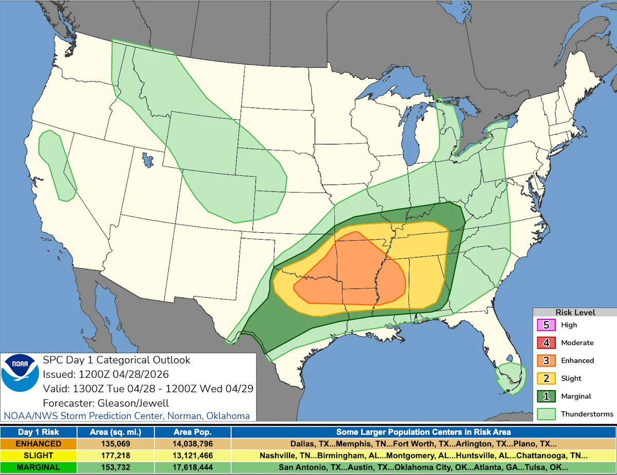
Storms that swept across the Midwest and Great Lakes overnight triggered warnings across several states as a powerful spring weather system moved east, though only a small number of tornadoes had been confirmed by April 28.

At least one person was killed late Monday in Kent County, Michigan, during the storms. Authorities say a 39-year-old man from Solon Township died after a tree fell during a passing thunderstorm, NBC News reported.

Responders found the man at the scene, and the Kent County Sheriff’s Office said he had been struck by the fallen tree. He was pronounced dead at the scene.

The overnight storms were part of a broader severe weather outbreak that is expected to continue April 28 as the system pushes farther east and new storms develop to the south.

Severe storms are now expected to remain active through at least midweek, with the Storm Prediction Center warning of multiple rounds of thunderstorms capable of producing very large to giant hail, damaging winds and a few tornadoes Tuesday, followed by additional scattered severe weather potential Wednesday.

"Multiple rounds of severe thunderstorms will occur across parts of the southern Plains into the lower Mississippi/Tennessee Valleys and Southeast through this evening," the Storm Prediction Center wrote for Tuesday's severe weather outlook. "Very large to giant hail (2-4+ inches), swaths of severe/damaging winds, and a few tornadoes are all possible."

The outbreak comes during a volatile spring pattern that has brought back-to-back rounds of severe thunderstorms since late March, including hail, high winds and tornadoes.

The Storm Prediction Center has issued an Enhanced Risk for severe thunderstorms stretching from the southern Plains into the lower Mississippi Valley, Mid-South and parts of the Southeast, with the highest risk area centered on a broad corridor from North Texas, including the Dallas–Fort Worth region, through Arkansas and into parts of Mississippi.

Meteorologists say a large-scale upper-level trough over the Plains is helping drive a series of disturbances that will move east through the day. At the surface, moisture continues to surge northward from Texas into Oklahoma and the lower Mississippi Valley, fueling a very unstable environment.

Elevated supercells are already ongoing in western North Texas early Tuesday, April 28, with additional storm development expected through the afternoon and evening.

Forecasters warn that storms will likely come in multiple rounds, with the potential for different hazards depending on timing and location.

Key threats include:

Very large to giant hail, up to 2 to 4 inches in diameter or larger

Damaging wind swaths, especially as storms cluster and move east

A few tornadoes, particularly with discrete supercells

Tornado watch issued? Here's what to do when sirens go off

Elevated thunderstorms are already underway in western North Texas early Tuesday, with more storms expected to form this afternoon along a boundary between hot, dry air and warm, humid air in the region. Forecasters say parts of North Texas into the ArkLaTex are especially primed for strong storms, with a very unstable atmosphere that can quickly fuel rapid storm development and strong wind patterns that support rotating storms, according to the Storm Prediction Center.

"A cold front and dryline will bring a chance of thunderstorms today and tonight, some of which may be severe," the National Weather Service in Fort Worth-Dallas wrote. "The highest severe weather threat will likely be this afternoon and evening for areas near and east of I-35."

The storms come just three days after a deadly storm and tornado break out killed two in Runaway Bay, Texas, according to NBC News.

As storms move east into Arkansas and the lower Mississippi Valley later in the day, forecasters expect some evolution into larger storm clusters, which may shift the dominant threat toward more widespread damaging winds while still supporting hail and isolated tornadoes. Farther north into the Tennessee Valley, the atmosphere is expected to recover behind morning convection, potentially allowing additional storms to redevelop later Tuesday into the evening.

Looking ahead to Wednesday, a Marginal Risk of severe weather remains in place from southern Texas through the north-central Gulf Coast and into parts of the Mid-Atlantic, according to the Storm Prediction Center's outlook for Wednesday.

While coverage is expected to be more scattered, isolated strong to severe storms could still produce hail and gusty winds, particularly where daytime heating and lingering boundaries overlap. Additional storm development is also possible across the Appalachians into the Mid-Atlantic as an upper-level system approaches from the west.

Despite tornado warnings across the Midwest and Great Lakes overnight, preliminary data from the Storm Prediction Center early Tuesday shows only three confirmed tornadoes.

Those reports came from Illinois and Arkansas, though officials caution the numbers are still preliminary and could change as National Weather Service damage surveys continue over the coming days.

The reported tornadoes include:

Germantown, Illinois, in Clinton County, where large trees and street signs were reported down around 1:08 a.m. local time

Near Hanover, Arkansas, in Stone County, where a radar-confirmed tornado was reported around 3:31 a.m.

Near Greenfield, Arkansas, in Craighead County, where multiple reports and social media images showed a rope tornado near Highway 1 and County Road 452 around 5:48 a.m.

A high number of tornado warnings does not always translate into a high number of confirmed tornadoes. Warnings are issued when radar shows rotation or conditions are favorable for a tornado, meaning they often cover storms that do not fully produce one or produce brief, weak touchdowns that take time to confirm.

More: Is a Super El Niño coming? How it could shape your weather

Brandi D. Addison covers weather across the United States as the Weather Connect Reporter for the USA TODAY Network. She can be reached at baddison@gannett.com. Find her on Facebook here.

This article originally appeared on USA TODAY: Tornadoes, giant hail possible as fresh storms target Midwest, South